How to Use Air Drones for Photography and Aerial Mapping?
In recent years, air drones have transformed the fields of photography and aerial mapping. These innovative devices capture stunning images from new perspectives. With advancements in technology, air drones now offer high-quality cameras and reliable flight capabilities. Photographers and surveyors alike appreciate the versatility that air drones provide.
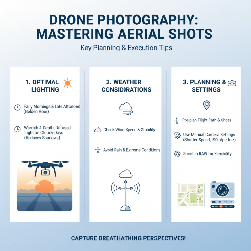
Using an air drone isn’t always straightforward. Beginners may struggle with control and settings. Familiarizing oneself with the flight dynamics is crucial for capturing impressive shots. Many users also need to consider weather conditions, as wind can significantly affect drone performance. Additionally, there are varying regulations regarding drone use, and understanding these is essential.
Yet, the potential of air drones is immense. They can create detailed maps and stunning images that were previously hard to achieve. With practice and patience, users can master these tools. The blend of creativity and technology opens up possibilities in both art and science. Embracing this technology requires critical thinking and continuous learning.
Understanding Different Types of Air Drones for Photography and Mapping
Aerial photography and mapping rely heavily on various types of air drones. They come in different sizes and capabilities, each suited for specific tasks. For instance, multi-rotor drones are agile. They excel in capturing high-resolution images over small areas. These drones are user-friendly, perfect for photographers new to aerial work. However, they often face battery life limitations, which can cut a session short.
Fixed-wing drones, on the other hand, cover large areas efficiently. They have longer flight times, making them suitable for extensive mapping projects. These drones fly at higher altitudes, capturing broader landscapes. While they offer stability and endurance, they require more expertise to operate. New users may find this challenging.
Another type is the hybrid drone, combining features of both fixed-wing and multi-rotor models. Though versatile, they can be complex to manage. Each drone type presents its own hurdles, like weather dependency and technical malfunctions. Understanding these differences is key to effectively using drones for photography and mapping. Finding the right balance between ease of use and functionality can be a learning curve.
Choosing the Right Camera and Equipment for Aerial Tasks
When it comes to aerial photography and mapping, selecting the right camera is crucial. A good camera captures vibrant colors and sharp details. Many photographers prefer cameras with interchangeable lenses for versatility. This feature allows changes depending on the scene. A wide-angle lens is particularly useful for expansive landscapes. It enables a broader perspective, making images more dynamic.
In addition to the camera, other equipment is vital. Gimbals stabilize the camera, reducing shake. This stabilization is essential for capturing smooth video footage. You may also consider additional batteries to extend flight time. Carry extra memory cards as well; they often run out quickly during shoots. Remember, clouds and weather can impact visibility. Test your gear in different conditions to understand its limits.
Choose your settings carefully. High shutter speeds are great for fast-moving subjects. But, they can underexpose in low light. Experiment with different settings to find what works best. Collecting stunning aerial shots takes practice and patience. A single flight session may not yield perfect results every time. Reflect on each experience, and learn from what doesn't work.
How to Use Air Drones for Photography and Aerial Mapping
| Camera Type |
Resolution (MP) |
Optimal Flight Altitude (m) |
Battery Life (minutes) |
Weight (g) |
| Mirrorless |
20 |
120 |
30 |
800 |
| DSLR |
24 |
100 |
25 |
1000 |
| Compact |
16 |
80 |
35 |
600 |
| Action Cam |
12 |
60 |
40 |
300 |
Essential Regulations and Safety Guidelines for Drone Operations
When operating drones for photography and aerial mapping, adherence to regulations is crucial. Always check local laws and regulations. Many regions require permits for commercial use. Understanding airspace classifications can prevent accidents. For instance, flying near airports is often restricted. Ignoring these guidelines can lead to serious consequences.
Safety is another key concern. Drones should be flown in clear weather conditions. Avoid high wind areas to prevent crashes. Ensure you have a stable control over the drone. Pre-flight checks are essential. Inspect battery levels and propellers before takeoff. Sometimes, people overlook small issues, which can lead to failures mid-air.
Respecting privacy is equally important. Be mindful of your surroundings. Avoid flying over private properties without permission. Communicate with people nearby to avoid disturbances. Some operators might find this inconvenient, but it builds trust. Reflection is part of safe drone operations. Regularly reassess your flying practices for better safety and compliance.
Drone Photography and Aerial Mapping Usage Trends (2023)
Processing and Analyzing Aerial Data for Mapping Purposes
Processing and analyzing aerial data for mapping purposes requires careful attention to detail. After capturing images with aerial drones, the next step is to convert images into useful data. This process often involves photogrammetry, which helps create 3D models from 2D images. With good overlap between images, the models can achieve high accuracy. Using software tools, users can stitch together the photos. This provides a comprehensive view of the mapped area.
Once the stitching is complete, it's time to analyze the data. This stage can identify land use patterns or assess environmental conditions. Take care to validate the data against ground truth measurements. Sometimes, inaccuracies emerge from poor image quality or insufficient coverage, which can lead to misleading conclusions. Adjusting flight paths or improving hardware can significantly enhance outcomes. Regularly reviewing methods and procedures is essential for continuous improvement.