Top Uses of Infrared Drones: Why They're Essential for Modern Aerial Surveys
The evolution of aerial surveying has been dramatically transformed by the integration of advanced technologies, particularly infrared drones. These sophisticated tools harness infrared radiation to provide detailed insights and data that were previously unattainable with traditional methods. As industries such as agriculture, construction, and environmental monitoring increasingly rely on precise and efficient surveying techniques, the role of infrared drones has become essential.
Infrared drones can detect temperature variations, visualize thermal patterns, and identify anomalies in various settings, thereby enhancing the accuracy of data collection and analysis. Their ability to operate in diverse environments and conditions further solidifies their importance in modern aerial surveys. As we explore the top uses of infrared drones, we will uncover how they are revolutionizing practices across multiple sectors, offering unparalleled advantages in efficiency and effectiveness. This discussion will highlight the transformative potential of infrared drone technology, illustrating why it is an indispensable tool for today's surveyors and decision-makers.
Top Uses of Infrared Drones in Aerial Surveys
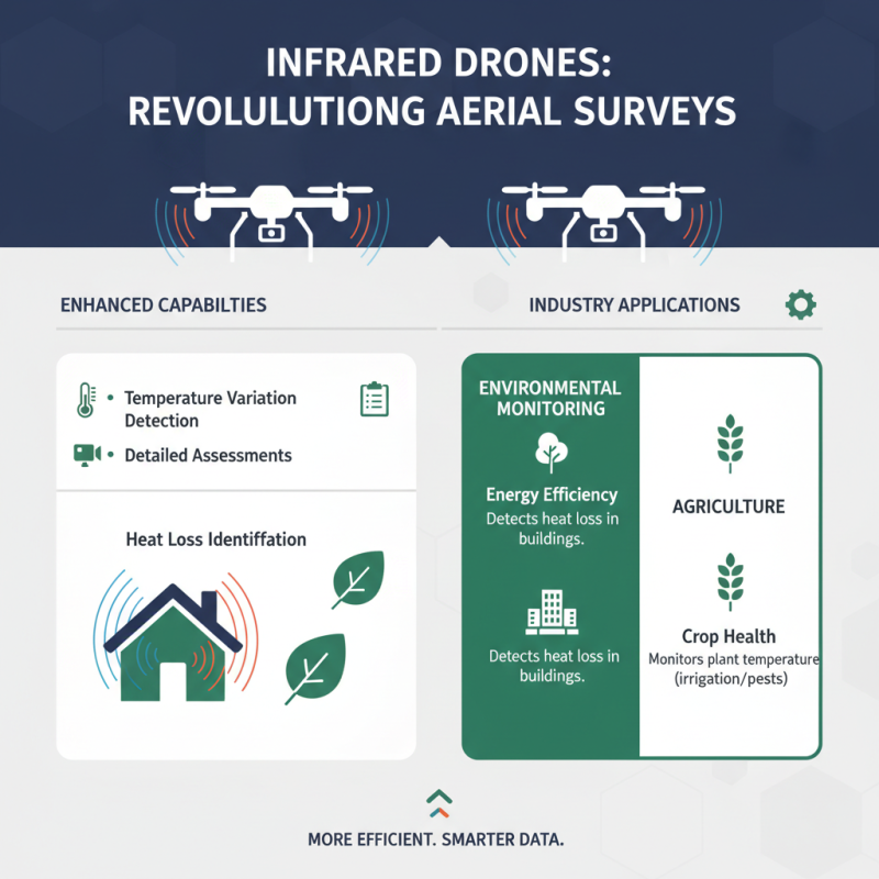
Infrared drones have revolutionized aerial surveys by offering enhanced capabilities that traditional surveying methods lack. These advanced drones utilize infrared technology to detect temperature variations and make detailed assessments in various industries. In environmental monitoring, for example, they can identify heat loss in buildings, allowing for more efficient energy management. In agriculture, infrared drones help monitor crop health by detecting variations in plant temperature, indicating irrigation needs or pest infestations.
Tips: When planning an aerial survey using infrared drones, it's essential to have a well-defined flight plan to maximize coverage and data quality. Additionally, operators should familiarize themselves with the camera settings and calibration processes to ensure accurate temperature readings. Regular maintenance and software updates will enhance the drone's performance and reliability.
Moreover, infrared drones play a critical role in infrastructure inspections. They can quickly scan bridges, power lines, and pipelines for potential issues that may not be visible to the naked eye. The ability to perform these inspections without the need for scaffolding or extensive manual labor saves time and reduces costs. Taking advantage of this technology can lead to safer and more efficient operations across various sectors.
Understanding Infrared Technology in Drone Applications
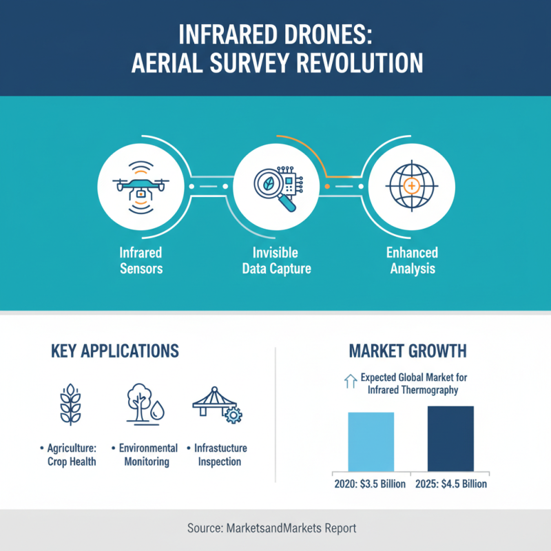
Infrared technology has transformed the capabilities of modern drones, making them indispensable tools for various aerial survey applications. By utilizing infrared sensors, drones can capture data that is not visible to the naked eye, allowing for enhanced analysis in fields such as agriculture, environmental monitoring, and infrastructure inspection. According to a report by MarketsandMarkets, the global market for infrared thermography is expected to grow from $3.5 billion in 2020 to $4.5 billion by 2025, highlighting the expanding role of infrared technology across industries.
The importance of infrared drones lies in their ability to detect temperature variations and identify potential issues before they escalate. For instance, in agricultural applications, drones equipped with infrared cameras can assess crop health by measuring plant temperatures and identifying areas that require more water or nutrients. Additionally, the construction and energy sectors utilize infrared drones for monitoring insulation integrity and detecting heat loss in buildings, significantly reducing operational costs and improving efficiency. A study by DroneDeploy found that 90% of surveyed construction professionals believe that drone technology improves project workflow by providing detailed insights that contribute to effective decision-making.
As more industries recognize the advantages offered by infrared drone technology, the integration of such tools into regular operations will likely become standard practice. The efficiency and accuracy of infrared data collection enable businesses to streamline processes and enhance their overall productivity, paving the way for smarter, data-driven decision-making in a rapidly evolving landscape.
Healthcare Monitoring: Infrared Drones in Medical Surveys
Infrared drones are becoming increasingly significant in modern healthcare, particularly in medical surveys. These advanced aerial vehicles utilize infrared technology to monitor and assess patients' health conditions from afar. By detecting temperature variations on the skin surface, infrared drones can help identify potential health issues, such as fevers or inflammation, without the need for direct contact. This capability is especially useful in scenarios requiring rapid assessments, such as during public health emergencies or in remote areas where traditional medical services may be limited.
When using infrared drones for healthcare monitoring, it's essential to ensure that the equipment is calibrated correctly for accurate readings. Here are a few tips to keep in mind: First, always verify the environmental conditions prior to deployment; factors such as weather and sunlight can affect infrared readings. Additionally, collaborating with healthcare professionals during the survey can help interpret the data accurately and provide context for any anomalies detected.
Moreover, maintaining patient privacy is crucial when utilizing drones for medical surveys. It is important to establish protocols that secure sensitive information and adhere to ethical standards. By implementing these practices, healthcare professionals can leverage the capabilities of infrared drones to enhance medical surveys, ultimately leading to better patient care and timely interventions.
Top Uses of Infrared Drones: Why They're Essential for Modern Aerial Surveys - Healthcare Monitoring: Infrared Drones in Medical Surveys
| Application Area |
Benefits |
Key Metrics |
Usage Frequency |
| Patient Monitoring |
Real-time health tracking |
Temperature variance < 0.5°C |
Daily |
| Disease Outbreak Surveillance |
Early detection of abnormalities |
Alert response time < 24 hours |
Weekly |
| Building Inspections |
Identifying temperature leaks |
Efficiency gains of 15%+ |
Monthly |
| Infrastructure Health Monitoring |
Detecting overheating equipment |
Reliability increase of 20% |
Quarterly |
| Emergency Response |
Rapid assessment of affected areas |
Response time < 1 hour |
As needed |
Agricultural Advancements: Utilizing Infrared Drones for Crop Analysis
The use of infrared drones in agriculture has revolutionized crop analysis, offering farmers unprecedented insights into the health and growth of their plants. Through thermal imaging, these drones can detect subtle variations in plant temperature, which is often an indicator of water stress or disease. By capturing this critical data from above, farmers can make informed decisions regarding irrigation, fertilization, and pest control, ultimately enhancing yield and reducing resource wastage.
Moreover, infrared technology allows for the monitoring of large swathes of land quickly and efficiently, something that traditional methods lack. This high level of efficiency means that farmers can regularly assess their fields, leading to timely interventions that improve crop resilience. The ability to visualize plant health through infrared imaging not only aids in immediate agricultural practices but also contributes to long-term planning and sustainability, ensuring that farming techniques can adapt to changing environmental conditions.
Environmental Assessments: Infrared Drones in Ecological Monitoring
Infrared drones have revolutionized environmental assessments, making them an indispensable tool for ecological monitoring. These advanced aerial devices can capture thermal images that reveal critical information about wildlife habitats, vegetation health, and land use changes. By analyzing heat patterns, researchers can identify areas of stress in ecosystems that may not be visible through conventional observation methods. This is particularly important for detecting water shortages in vegetation or monitoring the temperature variations in different wildlife habitats, enabling timely interventions to mitigate potential ecological risks.
Tips: When using infrared drones for ecological monitoring, ensure that you calibrate your sensors appropriately to capture the most accurate data. Be mindful of the time of day you operate the drone; early morning or late afternoon flights often yield clearer thermal images due to lower ambient temperatures. Additionally, consider incorporating regular maintenance checks on your drones to prolong their lifespan and ensure consistent performance.
Moreover, infrared drones are instrumental in tracking changes over time, helping scientists establish trends in environmental health. This data is crucial for developing conservation strategies and assessing the impact of climate change on different ecosystems. The integration of infrared technology in aerial surveys not only enhances the accuracy of environmental assessments but also supports efforts to preserve biodiversity and promote sustainable land practices.